mobile

Heritázs

  • Search
  • Collections
Englishen
  • Magyarhu
  • Српскиsr
  • Serbo-Croatiansh
LoginRegister
  • Volume Overview
  • Page
  • Text
  • Metadata
  • Clipping
Preview
mps_000081/0000

A New Map Of The Electorate Of Bavaria

  • Preview
  • Show Metadata
  • Show Permalink
Total Pages
2
Collection
Demo gyűjtemény, Térképek
mps_000081/0001
  • Volume Overview
  • Page
  • Text
  • Metadata
  • Clipping
Page 2 [2]
  • Preview
  • Show Permalink
  • JPG
  • TIFF
  • Prev
mps_000081/0001

OCR

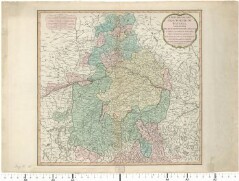
Cím : A New Map Of The Electorate Of Bavaria | Comprehending The Dutchy Of Bavaria, Divided Into Upper And Lower Bavaria; The Upper Palatinate, The Palatinates or Dutchies Of Neuburg and Sulzbach, The Principality of Mindelheim & c. Mafkstab in graph. Form (German Miles, Bavarian Miles) [London] | Laurie & Whittle Laurie, Robert | Whittle, James 01.01.1794 Altkarte urn:nbn:de:bvb:12-bsb00010741-2 | http://nbn-resolving.de/urn/resolver.pl?urn=urn:nbn:de:bvb:12-bsb00010741-2 Bayern | Bayerischer Reichskreis

Structural

Custom

Image Metadata

Image width
2480 px
Image height
3509 px
Image resolution
300 px/inch
Original File Size
373.07 KB
Permalink to jpg
mps_000081/0001.jpg
Permalink to ocr
mps_000081/0001.ocr

Privacy

  • Privacy policies
  • Cookies

  • https://facebook.com/tripont

Website

  • heritazs.hu
  • phaseone.hu
  • tripont.hu
  • tripont.hu/problog

Contact

  • +36 30 462 23 40
  • klinger.gabor@tripont.hu
  • 1131 Budapest,
  • Reitter Ferenc utca 132/J.

  • Copyright © 2023 Tripont Kft.
  • Copyright © 2024 Tripont Kft.

Heritázs

LoginRegister

User login

I forgot my password
  • Search
  • Collections
Englishen
  • Magyarhu
  • Српскиsr
  • Serbo-Croatiansh